seamus dubhghaill

Promoting Irish Culture and History from Little Rock, Arkansas, USA


Leave a comment

Storm Frank Causes Widespread Flooding

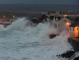
Clean-up operations are underway around Ireland on Wednesday, December 30, 2015, in the wake of Storm Frank, which causes widespread flooding following its landfall in western areas on Tuesday, December 29. Thousands of households and businesses are left without electricity in many areas of the country.

A Met Éireann status orange wind warning is lifted at 2:00 p.m. on Wednesday although the forecasts caution that severe winds of 65-80 km/h and gusts of up 130 km/h are still expected. While the heaviest rainfall from the storm falls overnight, many rivers and lakes have yet to peak meaning further flooding is possible.

According to an ESB Networks spokesman, 7,500 homes are without power in the afternoon, down from the overnight total of 13,000. He says repair crews are working to restore power to those cut off. The biggest single outage overnight is around Bandon and Fermoy in County Cork where 4,000 homes are without power, although it has been restored to almost all homes by the afternoon of December 30.

At 2:00 p.m. on Wednesday, the worst affected areas are County Wicklow with 1,200 houses without power, Macroom in County Cork where 600 are without power and Athlone where 500 homes are cut off. Around 500 homes in Naas, County Kildare, are without power as are 350 houses in Skerries in north County Dublin. It is hoped that power will be restored to all customers by the evening.

County Cork appears to be the worst affected by the storm where 60 mms (almost three inches) of rain falls since the morning of December 29. The threat of further flooding in Cork remains as the ESB increases the flow of water through the Inniscarra Dam to 250 cumecs (cubic metres per second) between 9:00 a.m. and midday which leads to increased flooding downstream. This is higher than the level of flow (180 cumecs) the previous and between December 6 and 12 along the River Lee following Storm Desmond.

Cork County manager Tim Lucey says there has been “extensive flooding” across a range of areas, but that Midleton and Bandon are worst hit with some 90 properties affected in each of the towns. He tells RTÉ Radio that one positive is the fact flood defences in Mallow and Fermoy have done their job. He notes that some five feet of water has built up behind a flood barrier in Mallow and this indicates the damage that could have been done to the town.

South Galway bears the brunt of flooding in the west, with river gauges expected to rise further over the coming days. Overnight rainfall is not as heavy as anticipated in the west, but several properties succumb to the waters. Up to 30 families in the south Galway area are forced to stay with relatives, with several being accommodated in hotels by Galway County Council, as floodwaters cut off access routes to their homes.

In Mayo, the area around the Neale remains underwater and a number of minor roads and thousands of acres of farmland are also affected. With rain continuing to fall across the west, conditions are expected to remain critical over the next few days.

The N11 between Rosslare and Dublin, the N25 from Cork to Waterford, the N71 between Cork and Killarney and the N4 between Dublin and Sligo all have diversions in place. The N25 is closed overnight between Killeagh and Castlemartyr in County Cork due to flooding. The N71 Cork/Bandon Road is also closed overnight at the viaduct due to flooding. There is severe flooding on the N40 South Ring Rd. at J6 Kinsale, particularly on the westbound off-ramp. The N11 Dublin/Wexford Road is impassable through Enniscorthy and also at Kyle’s Cross near Oylegate. The N4 is closed eastbound at Ballynafid in County Westmeath due to flooding. There are also several road closures in Kerry, Waterford and Tipperary.

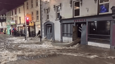
Midleton is also hit by severe flooding as water levels in the Owenacurra River rise dramatically with up to 30 families having to be evacuated from their homes. Macroom in mid-Cork is also flooded for the first time during the year. Bandon is put on red alert by Cork County Council’s early warning system. Traders and residents are told to take all measures necessary to protect their property and stock. Locals stay up all night preparing the town for the latest round of flooding. Nevertheless, some 20 businesses in Bandon are flooded for the second time in a month after waters start to come up shores and gutters in the town as water levels in the River Bandon rise overnight.

The River Slaney burst its banks in Enniscorthy, County Wexford, causing widespread flooding in the town. Several cars have to be abandoned. High tide in Enniscorthy occurs around 10:30 a.m. on December 30.

Limerick City Council and Limerick County Council say there has been no significant flooding in the county as a result of overnight rainfall but that water levels along the lower River Shannon continue to increase. Water levels on the river rise by some 11cm at Castleconnell and Montpelier.

The ESB says the flow of water through Parteen Weir, which regulates water flow through Ardnacrusha power plant, will remain at 440 (cubic metres per second) on December 30 and that the situation will be reviewed again the following day. “The levels in Lough Derg may reach 2009 levels in the coming days and, as a result, the flow through Parteen Weir may increase to 2009 levels (up to 500 cumecs) in the coming days,” it says.

Clare County Council says water levels on the lower River Shannon at Springfield, Clonlara, have increased by 5-10cm in the last 24 hours and are some 20cm below a peak level recorded on December 13th. It says the Mulkear River in County Limerick, which enters the River Shannon south of Annacotty, is currently in flood and is contributing to increased water levels at Springfield. Council staff are assisted by the Fire Service and Defence Forces at Springfield in their pumping operations and transporting residents of some 12 homes isolated by floodwaters.

Fianna Fáil urges Taoiseach Enda Kenny to call an emergency Cabinet meeting to address the fallout from the storm. The party’s environment spokesman, Barry Cowen, says many communities felt neglected as further significant damage was inflicted on homes and businesses by the rainfall and winds brought by Storm Frank. “The scenes that we are witnessing in communities impacted by the latest storm are truly heart-breaking,” he says. “People feel neglected by the Government. It’s astonishing that the Taoiseach has decided not to interrupt his Christmas holidays in light of the devastation caused by Storm Frank.”

The Government’s National Coordination Group on Severe Weather meets in Dublin on December 30. Sinn Féin MEP Liadh Ní Riada says the Government has displayed “ineptitude in preparing flood defences” and that “more hollow promises” from the Coalition are no substitute for action. “The risk of flooding is increasing and will continue to increase. People across this island need to know that our political leaders have a plan to prevent this happening in the future,” she says.

(From: “Storm Frank causes floods, closes roads and cuts power to thousands” by Ronan McGreevy, Th Irish Times, http://www.irishtimes.com, December 30, 2015 | Pictured: Water flows through buildings and down the street in Graignamanagh, Co Kilkenny on Tuesday night by Paul B via Twitter)


Leave a comment

The Shipwrecks of the Trevor and Nonpareil

Two hundred passengers are lost in the shipwrecks of the brigs Trevor and Nonpareil on October 20, 1775. Among the casualties are The Hononorable Major Francis Caulfield, Member of Parliament (MP) for Charlemont, his wife, and daughters. Also lost is John French, Member for Roscommon County.

On Thursday, October 19, 1775, the brig Trevor, with Captain William Totty at the helm, and the brig Nonpareil, with Capatin Samuel Davies, sail from Parkgate for Dublin. That evening, as the vessels are near Holyhead, the wind shifts about from the south southwest to the west, and so violent a hurricane arises that they cannot carry any sail, but are obliged to lie to, and drive before the wind. In this situation, the Trevor drives upon the banks near the Lancashire shore, and is totally lost.

Everyone on board perishes, except Samuel Fairclough, a mariner, who miraculously saves his life by leaping aboard another vessel named the Charming Molly, under Captain Joseph Holloway, which is transporting coal from Chester to Newry. The Charming Molly accidentally runs foul of the Trevor and carries away the Trevor‘s fore-topmast and, at the instant the two vessels come together, Fairclough makes his leap. He was the only survivor of the 30 to 40 passengers and crew aboard the Trevor.

Captain Holloway states that his vessel and the Trevor came together at some distance from the coast. They parted at the time Fairclough jumped across, and the Trevor subsequently went to pieces. A great many chests, boxes, some of which are broken, and quantities of East India goods are strewn along the shore, all wet with salt water. These items are in the custody of Mrs. Hesketh, Lady of the Manor of this coast, secured by Mr. Standen of Rossall Hall. The East India goods had arrived by land from London. The cargo and coins aboard the Trevor are estimated to be worth £15,000.

The Charming Mary runs ashore at Blackpool with most of her sails carried away, but otherwise with little damage.

The Nonpareil is lost in the storm between Parkgate and Dublin, driven on shore near Hoyle-sands and lost. There are no survivors. The wife of Captain Davies states that her husband sailed from Parkgate with very low spirits as he did not like the appearance of the weather. He is pressured to put to sea, which he does, and is turned back twice, but gets off on the third attempt, and is never seen again.

Between them, the Trevor and the Nonpareil reportedly carry nearly 200 passengers, the majority being on the Nonpareil. They carry cargo valued at £15,000.

On Tuesday evening, October 24, the Collector of the port of Chester receives the melancholy account of the loss of the Trevor by a letter from the Collector of Poulton, in Lancashire. This is immediately communicated to the Merchants, who are concerned in shipping the cargo, and they set out as soon as possible to give assistance and to secure each part of the cargo as might come ashore.

The merchants from Chester reach Poulton late on Wednesday night, October 25. The following morning they set out along the shore from Blackpool, where the Charming Mary is stranded. The greatest part of the hull of the Trevor lay scattered along the shore at a great distance. On their arrival at Rossall Hall, about six miles from Blackpool, they have the satisfaction to find that Mr. Standen, who is Steward of the Manor of Bold Fleetwood Hesketh, now a minor and son to the deceased Fleetwood Hesketh, on whose estate the wreck is taken up, has taken all possible care of everything that can be saved from plunderers.


Leave a comment

Storm Eva Cuts Power to 6,000

On December 24, 2015 the Electricity Supply Board networks says that around 6,000 customers are without power as a result of Storm Eva. The worst affected areas are Fermoy in County Cork and Kilcoole in County Wicklow. High winds and heavy rain batter the west and northwest as Storm Eva moves across the country.

Storm Eva, also called Chuck, Staffan and other names, is the fifth named storm of the Met Office and Met Éireann‘s Name our Storms project. Heavy rainfall from Eva occur around three weeks after Storm Desmond had brought severe flooding to parts of Northern England, exacerbating the ongoing situation. The low pressure is named Chuck by the Free University of Berlin and Staffan by the Swedish Meteorological and Hydrological Institute.

Eva is the fifth storm to be officially named by Met Éireann on December 22, 2015. An orange wind warning is issued for counties Clare, Galway, Mayo, Sligo and Donegal on the same day. Gales are also expected in the northwest of the United Kingdom, with storm force winds over parts of the Outer Hebrides. There are fears that the storm could cause further disruption to Cumbria in England, where areas were already dealing with the aftermath of flooding from Storm Desmond and in some cases had been flooded twice already. The army and Environment Agency staff are called in to be on stand-by to bolster flood defences.

Rain associated with the passage of Eva causes disruption when rivers burst their banks in the Cumbrian towns of Appleby-in-Westmorland, Keswick and Kendal on the December 22. Appleby-in-Westmorland receives three to four feet of flood water. The village of Glenridding is flooded for the third time in the month. Six thousand houses in Ireland are left without power. In London, Secretary of State for Environment, Food and Rural Affairs Liz Truss convenes a Cabinet Office Briefing Rooms (COBR) meeting to decide on emergency measures, which include the deployment of soldiers from the 2nd Battalion, Duke of Lancaster’s Regiment to the affected areas. On December 24, flood defence gates are closed in Carlisle, Keswick and Cockermouth to limit the damage expected from rainfall and 20 water pumps and two kilometres of temporary flood barriers are transported to northern England. Ferries operating between Dublin and Holyhead are cancelled due to bad weather on the Irish Sea.


Leave a comment

The 1947 Blizzard

blizzard-of-1947The worst blizzard in living memory hits Ireland on February 25, 1947. The penetrating Arctic winds had been blowing for several weeks. Munster and Leinster had been battling the snows since the middle of January.

On the evening of February 24, a major Arctic depression approaches the coast of Cork and Kerry and advances northeast across Ireland. By morning, Ireland is being pounded by the most powerful blizzard of the 20th century. The winter of 1946-1947 is the coldest and harshest winter in living memory. Temperatures rarely rise above freezing and the snows that have fallen across Ireland in January remain until the middle of March.

Worse still, all subsequent snowfall in February and March simply piles on top of all that has previously fallen. There is no shortage of snow that bitter winter. Of the fifty days between January 24 and March 17, it snows on thirty of them.

“The Blizzard” of February 25th is the greatest single snowfall on record and lasts for almost fifty consecutive hours. It smothers the entire island in a blanket of snow. Driven by persistent easterly gales, the snow drifts until every hollow, depression, arch and alleyway is filled and the Irish countryside becomes a vast ashen wasteland.

Everything on the frozen landscape is a sea of white. The freezing temperatures solidify the surface and it is to be an astonishing three weeks before the snows begins to melt.

(Pictured: Snow drifts on Main Street, Boyle, County Roscommon, February 1947)


Leave a comment

Hurricane Debbie Strikes Ireland

hurricane-debbieHurricane Debbie, the most powerful cyclone on record to strike Ireland in September and possibly the only tropical cyclone on record to ever strike the British Isles while still tropical, makes landfall in Ireland on September 16, 1961.

The fourth named storm of the 1961 Atlantic hurricane season, Debbie originates from a well-defined tropical disturbance that is first identified in late August over Central Africa. Tracking generally westward, the system moves off the coast of Senegal on September 5 into the Atlantic Ocean. By this time, it is estimated to have become a tropical storm, but forecasters do not issue advisories on the system until two days later. Late on September 6, Debbie passes through the southern Cape Verde Islands as a strong tropical storm or minimal hurricane, resulting in a plane crash that kills 60 people in the islands. Once clear of the islands, data on the storm becomes sparse and the status of Debbie is uncertain over the following several days as it tracks west-northwestward and later northward. It is not until a commercial airliner intercepts the storm on September 10 that its location becomes certain. The following day, Debbie intensifies and reaches its peak intensity as a Category 3 hurricane on the Saffir–Simpson hurricane scale, with maximum winds of 120 mph.

Maintaining its peak intensity for over a day, the hurricane gradually slows its forward motion and weakens. By September 13, Debbie’s motion becomes influenced by the Westerlies, causing the system to accelerate east-northeastward. The system passes over the western Azores as a minimal hurricane on September 15. At this point, there is uncertainty as to the structure of Debbie, whether it transitions into an extratropical cyclone or maintains its identity as a tropical system. Regardless of which takes place, the system deepens as it nears the British Isles, skirting the coast of Western Ireland on September 16. Shortly thereafter, the system is confirmed to have become extratropical as it continues towards the northeast.

Striking Ireland as a powerful storm, Debbie brings record winds to much of the island, with a peak gust of 114 mph measured just offshore. These winds cause widespread damage and disruption, downing tens of thousands of trees and power lines. Countless structures sustain varying degrees of damage, with many smaller buildings destroyed. Agriculture experiences extensive losses to barley, corn, and wheat crops. Throughout Ireland, Debbie kills 18 people, twelve in the Republic of Ireland and six in Northern Ireland. It causes $40–50 million in damage in the Republic and at least $4 million in Northern Ireland. The storm also batters parts of Great Britain with winds in excess of 100 mph.

The remnants of the storm later turned eastward, striking Norway and Russia, before dissipating on September 19.